[ 3] Name on the Register[ 4]
Image
Date listed[ 5]
Location
City or town
Description
1
Air Science Air Science May 16, 1989 (#88001546 ) Northeastern corner of N. Horseshoe and Espina St. on the New Mexico State University campus 32°17′00″N 106°45′19″W / 32.283333°N 106.755278°W / 32.283333; -106.755278 (Air Science ) Las Cruces Today the William Conroy Honors Center
2
Alameda-Depot Historic District Alameda-Depot Historic District April 11, 1985 (#85000786 ) Includes properties centered around Pioneer Park and extending up Alameda Boulevard 32°18′45″N 106°47′01″W / 32.3125°N 106.783611°W / 32.3125; -106.783611 (Alameda-Depot Historic District ) Las Cruces
3
Nestor Armijo House Nestor Armijo House December 12, 1976 (#76001195 ) Lohman Ave. and Church St. 32°18′20″N 106°46′35″W / 32.305556°N 106.776389°W / 32.305556; -106.776389 (Nestor Armijo House ) Las Cruces
4
Barela-Reynolds House Barela-Reynolds House January 20, 1978 (#78001815 ) Off State Road 292 32°16′27″N 106°47′43″W / 32.274167°N 106.795278°W / 32.274167; -106.795278 (Barela-Reynolds House ) Mesilla State Historic Site
5
L.B. Bentley General Merchandise L.B. Bentley General Merchandise March 22, 2006 (#06000155 ) 16125 Old Organ Main St. 32°25′40″N 106°35′55″W / 32.427778°N 106.598611°W / 32.427778; -106.598611 (L.B. Bentley General Merchandise ) Organ
6
Thomas Branigan Memorial Library Thomas Branigan Memorial Library September 15, 2004 (#04000981 ) 106 W. Hadley St. 32°18′52″N 106°46′48″W / 32.314444°N 106.78°W / 32.314444; -106.78 (Thomas Branigan Memorial Library ) Las Cruces Original library building; replaced by newer facility in 1979
7
Camino Real-Rincon Arroyo-Perrillo Section Upload image April 8, 2011 (#11000172 ) Address Restricted Rincon
8
Camino Real-San Diego South Upload image April 8, 2011 (#11000165 ) Address Restricted Rincon
9
Camino Real-San Diego North South Section Upload image April 8, 2011 (#11000166 ) Address Restricted Radium Springs
10
Chope's Town Cafe and Bar Chope's Town Cafe and Bar May 26, 2015 (#15000262 ) 16145 NM 28 32°07′10″N 106°42′22″W / 32.1195°N 106.7062°W / 32.1195; -106.7062 (Chope's Town Cafe and Bar ) La Mesa
11
Doña Ana Village Historic District Upload image September 27, 1996 (#96001042 ) Roughly bounded by the Doña Ana lateral irrigation ditch, Interstate 25 , State Road 320 , and Doña Ana School Rd. 32°23′17″N 106°48′56″W / 32.388056°N 106.815556°W / 32.388056; -106.815556 (Doña Ana Village Historic District ) Doña Ana
12
Paul Laurence Dunbar Elementary School Paul Laurence Dunbar Elementary School February 7, 2017 (#100000630 ) 325 Holguin Rd. 32°07′06″N 106°39′46″W / 32.118213°N 106.662733°W / 32.118213; -106.662733 (Paul Laurence Dunbar Elementary School ) Vado
13
Elephant Butte Irrigation District Upload image August 8, 1997 (#97000822 ) Roughly along U.S. Route 85 between its junction with State Road 90 and the El Paso city limits 32°12′58″N 106°57′31″W / 32.216111°N 106.958611°W / 32.216111; -106.958611 (Elephant Butte Irrigation District ) Las Cruces Extends into Sierra County and El Paso County, Texas
14
Fort Fillmore Upload image July 30, 1974 (#74001196 ) Eastern side of Holy Cross Rd., southeast of Las Cruces[ 6] 32°15′28″N 106°44′36″W / 32.257877°N 106.743338°W / 32.257877; -106.743338 (Fort Fillmore ) Las Cruces
15
Fort Selden Fort Selden July 9, 1970 (#70000401 ) 18 miles north of Las Cruces 32°29′45″N 106°55′30″W / 32.495833°N 106.925°W / 32.495833; -106.925 (Fort Selden ) Radium Springs State Historic Site
16
Foster Hall Foster Hall May 16, 1989 (#88001547 ) Southeastern corner of the junction of S. Horseshoe and Sweet on the New Mexico State University campus 32°16′53″N 106°45′09″W / 32.281389°N 106.7525°W / 32.281389; -106.7525 (Foster Hall ) Las Cruces
17
Goddard Hall Goddard Hall September 22, 1988 (#88001548 ) S. Horseshoe between Espina and Sweet on the New Mexico State University campus 32°16′53″N 106°45′13″W / 32.281389°N 106.753611°W / 32.281389; -106.753611 (Goddard Hall ) Las Cruces
18
Green Bridge Green Bridge August 21, 2008 (#08000791 ) 4100 Dripping Springs Rd. 32°17′56″N 106°43′13″W / 32.29885°N 106.72015°W / 32.29885; -106.72015 (Green Bridge ) Las Cruces
19
Hadley-Ludwick House Hadley-Ludwick House April 3, 1991 (#91000352 ) 2640 El Paseo 32°16′59″N 106°45′42″W / 32.283056°N 106.761667°W / 32.283056; -106.761667 (Hadley-Ludwick House ) Las Cruces
20
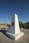
International Boundary Marker No. 1, U.S. and Mexico International Boundary Marker No. 1, U.S. and Mexico September 10, 1974 (#74001195 ) West of El Paso off Interstate 10 31°47′02″N 106°31′47″W / 31.783889°N 106.529755°W / 31.783889; -106.529755 (International Boundary Marker No. 1, U.S. and Mexico ) Sunland Park Border monument placed in 1855
21
Frank and Amelia Jones House Frank and Amelia Jones House July 25, 2014 (#14000444 ) 18000 Castillo Rd. 32°08′42″N 106°43′02″W / 32.1449°N 106.7171°W / 32.1449; -106.7171 (Frank and Amelia Jones House ) La Mesa
22
La Mesilla Historic District La Mesilla Historic District July 20, 1982 (#82003323 ) Roughly bounded by Calle del Norte, Calle del El Paso, Calle del Cura and Calleion Guerro 32°16′49″N 106°47′39″W / 32.280278°N 106.794167°W / 32.280278; -106.794167 (La Mesilla Historic District ) Mesilla
23
Launch Complex 33 Launch Complex 33 October 3, 1985 (#85003541 ) White Sands Missile Range 32°24′04″N 106°22′40″W / 32.401111°N 106.377778°W / 32.401111; -106.377778 (Launch Complex 33 ) White Sands Missile Range
24
Mesilla Park Elementary School Mesilla Park Elementary School February 23, 2015 (#15000039 ) 304 Bell Ave. 32°16′30″N 106°46′10″W / 32.275128°N 106.769487°W / 32.275128; -106.769487 (Mesilla Park Elementary School ) Las Cruces
25
Mesilla Park Historic District Upload image April 12, 2016 (#16000161 ) Bounded by Bowman St., Union and University Aves., and Park Drain 32°16′38″N 106°46′08″W / 32.277159°N 106.769024°W / 32.277159; -106.769024 (Mesilla Park Historic District ) Las Cruces
26
Mesilla Plaza Mesilla Plaza October 15, 1966 (#66000475 ) 2 miles south of Las Cruces on State Road 28 32°16′25″N 106°48′16″W / 32.273611°N 106.804444°W / 32.273611; -106.804444 (Mesilla Plaza ) Mesilla
27
Mesquite Street Original Townsite Historic District Mesquite Street Original Townsite Historic District August 1, 1985 (#85001669 ) Roughly bounded by E. Texas, Campo, Tornillo, and E. Court 32°18′31″N 106°46′26″W / 32.308611°N 106.773889°W / 32.308611; -106.773889 (Mesquite Street Original Townsite Historic District ) Las Cruces
28
Our Lady of Purification Catholic Church Our Lady of Purification Catholic Church June 27, 1985 (#85001386 ) Camino Real and 2nd St. 32°23′14″N 106°48′59″W / 32.387222°N 106.816389°W / 32.387222; -106.816389 (Our Lady of Purification Catholic Church ) Doña Ana
29
Phillips Chapel CME Church Phillips Chapel CME Church August 4, 2003 (#03000735 ) 638 N. Tornillo St. 32°18′54″N 106°46′25″W / 32.315°N 106.773611°W / 32.315; -106.773611 (Phillips Chapel CME Church ) Las Cruces
30
Rio Grande Bridge at Radium Springs Rio Grande Bridge at Radium Springs July 15, 1997 (#97000734 ) State Road 185 over the Rio Grande 32°29′11″N 106°55′31″W / 32.486393°N 106.925312°W / 32.486393; -106.925312 (Rio Grande Bridge at Radium Springs ) Radium Springs Timber beam bridge built in 1933.
31
Rio Grande Theatre Rio Grande Theatre January 2, 2004 (#03001352 ) 211 N. Downtown Mall 32°18′38″N 106°46′42″W / 32.310556°N 106.778333°W / 32.310556; -106.778333 (Rio Grande Theatre ) Las Cruces
32
San Jose Church San Jose Church January 21, 1993 (#92001817 ) 317 Josephine St. 32°07′23″N 106°42′16″W / 32.123056°N 106.704444°W / 32.123056; -106.704444 (San Jose Church ) La Mesa
33
Summerford Mountain Archeological District Upload image January 22, 2007 (#06001302 ) Address Restricted Radium Springs
34
Tortugas Pueblo Fiesta of Our Lady of Guadalupe Upload image August 7, 2017 (#100001437 ) Bounded by Emilia Rd., E. Guadalupe St., Juan Diego Ave., and Stern Dr. 32°16′11″N 106°45′10″W / 32.269696°N 106.752897°W / 32.269696; -106.752897 (Tortugas Pueblo Fiesta of Our Lady of Guadalupe ) Tortugas
35
University President's House University President's House May 16, 1989 (#88001549 ) South of University Ave. between Espina and Solano on the New Mexico State University campus 32°17′02″N 106°45′16″W / 32.283889°N 106.754444°W / 32.283889; -106.754444 (University President's House ) Las Cruces Now the Nason House


